
Start a New Windsor Street Directory Search
Address-based research in New Windsor works best as a chain. The public trail can establish land ownership and record history, but it does not establish every person connected with an address. First preserve the street number, road spelling, municipality, and any unit information. Then use the county map to identify the parcel, compare it with the assessment roll, and move to the deed index only after the parcel or legal description is known.
- Search the address in the Orange County GIS viewer and save the parcel identifier and property location.
- Compare the parcel with the New Windsor assessment roll or BAS tax search, keeping the situs and owner mailing fields separate.
- Use the owner, deed book and page, legal description, or SBL to enter the Orange County Clerk land-record trail.
- For an older address, check whether a historical directory is searchable by street for that year; earlier volumes may require a surname first.
- Ask the Building Department for a narrowly described permit or code record when the question concerns a dated project, not a list of people.
The state voter form is an individual identity match, not a public New Windsor street directory browse. It asks for a matched person’s identifying information, so it cannot fill the gap between parcel ownership and every current occupant.
New Windsor Street Directory GIS Fields
The Orange County parcel search accepts partial owner names and partial addresses, as well as a parcel ID. Its municipality scope can search all municipalities, a selected municipality, or the current map view. That makes it useful when a road crosses a boundary or when an address needs a second check. Search the parcel first, then use the map only to understand adjoining land and road geometry.
| GIS field | Use in a street search | Format or scope |
|---|---|---|
| Owner Name | Find a parcel connected to a recorded owner | Partial strings accepted |
| Address | Locate a street number or road | Partial address accepted |
| Parcel ID | Return to an identified parcel | County parcel or SBL identifier |
| Municipality scope | Limit or widen a result set | All, selected municipality, or current view |
The parcel-search instructions show the controls directly. Keep a search date with any saved result because parcel layers and assessment information can change.
The parcel-search documentation appears below. It is a starting point for a New Windsor street directory trail, not proof that a named person occupies the parcel.
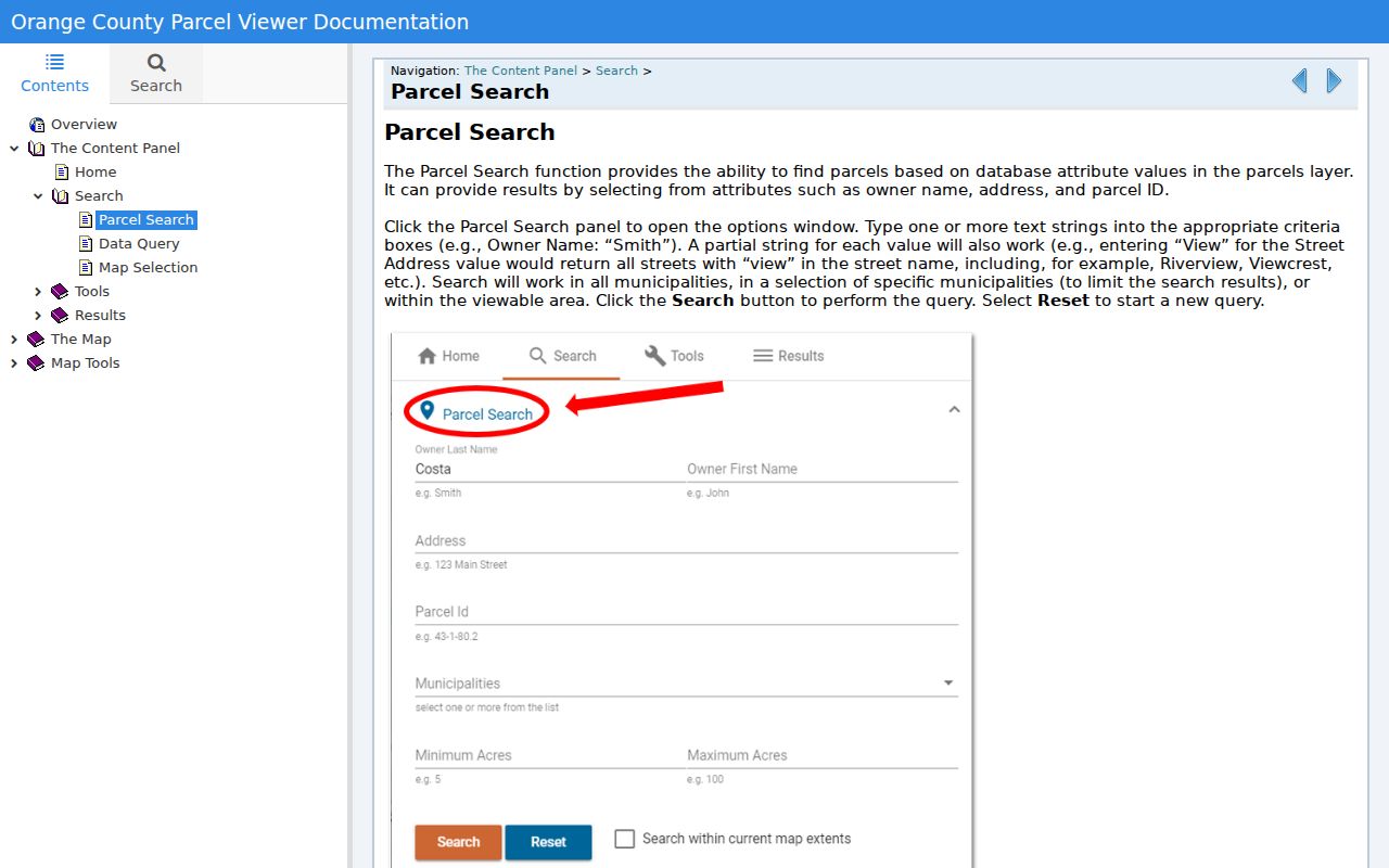
Use the result to collect a parcel key before comparing the roll or a recorded instrument.
New Windsor Street Parcel Details
After a map match, the Parcel Details tool can show property, owner, and community information. It also offers Wetlands, Floodplains, and Soils tabs, plus report save and print functions. Those environmental tabs describe land context, not residence. A street-by-street review should record only the parcel relationship and the source date, then use the roll or deed record for the separate ownership claim.
The assessment records make the address split clear. The 2036 Independence Drive sample printed property location and owner address separately even though they matched. The 27 Old Route 9W row instead showed St. Thomas Episcopal as owner with a PO Box 4221 mailing address. The property location was still 27 Old Route 9W. Do not substitute a mailing field for the mapped situs.
The official parcel-details documentation is shown here for the report and tab controls.
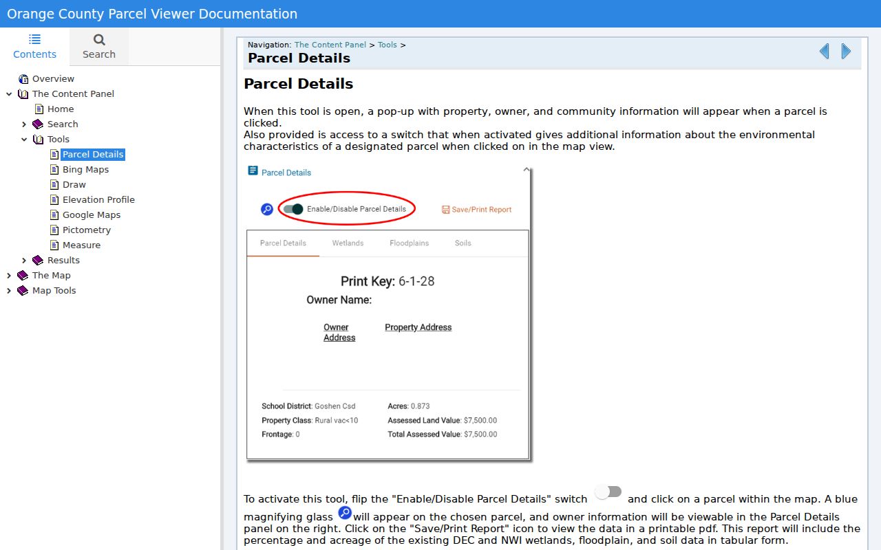
Read the pop-up as a parcel record, then confirm any title or mailing detail in the dated assessment material.
New Windsor Street Records Coverage
Several New Windsor sources are keyed to an address, but they answer different questions. The Assessor posts rolls for 2013 through 2026. BAS is a tax-bill search, while the GIS is the map and parcel layer. The County Clerk holds the recorded land trail. A permit file is an address-specific request route because no public town permit index was located.
| Address record | What it can show | New Windsor access route |
|---|---|---|
| Assessment roll | Assessed owner, situs, mailing address, class, value, and tax description | Assessor PDFs and office inspection |
| BAS tax search | Collection, bill, tax map, property address, and owner name | BAS New Windsor |
| GIS parcel viewer | Geometry, parcel details, owner/community pop-up, and adjacent land | County public viewer |
| Deed index and maps | Recorded parties, legal description, dates, and map references | County Clerk IQS, record room, and map room |
| Building or code file | Address and date-specific construction or inspection context when disclosable | Building Department or town FOIL request |
Use the number or road name to find the parcel, but rely on the SBL and legal description to connect the sources. The Assessor can clarify roll year and tax-map formatting. The Building Department can be reached at 845-563-4618 for a narrow permit or code request.
New Windsor Street Record Terms
Three identifiers prevent an address search from drifting. Keep all three in notes, especially where a route number, subdivision, or old map label appears.
- Parcel
- A mapped unit of land used by the assessment and GIS systems. It may not match a household or a single building.
- Situs
- The property location printed in the roll. It is distinct from the owner’s mailing address.
- SBL
- A tax-map parcel identifier. New Windsor examples include 76-4-13 and 9-2-7.2; ask the assessor to interpret a particular format.
- Plat or subdivision map
- A recorded map that can link a lot and block to a parcel when a postal street number is absent from an older deed.
- Criss-cross directory
- A directory arranged by address rather than only by surname, useful for historical household context where a street index exists.
Lot, block, and subdivision text can be more stable than a street number. A deed can use a metes-and-bounds description or an older lot reference instead, which is why the map room remains part of a careful street directory search.
New Windsor Street Deed Chain
Recorded ownership is traced through the Orange County Clerk Online Records gateway, which leads to SearchIQS. The public gateway does not expose a confirmed current online cutoff, so treat the online system as one route rather than the whole record set. SearchIQS has a free Historical Only option with $0.50 per image, a one-day plan listed at $15 with $5 per document download or print, and other subscription plans. The Clerk’s historical grantor and grantee indexes and deed books A through 450 cover 1703 to 1900.
Start with the present owner as grantee near the acquisition date. Read the purchase deed for the seller, recording details, legal description, map references, and any earlier book or page. Then search that seller as an earlier grantee. If IQS access or coverage ends, use the Clerk’s record room and map room rather than guessing from the street number.
The County Clerk Online Records gateway below shows the account-gated SearchIQS entry used for deed-index access.
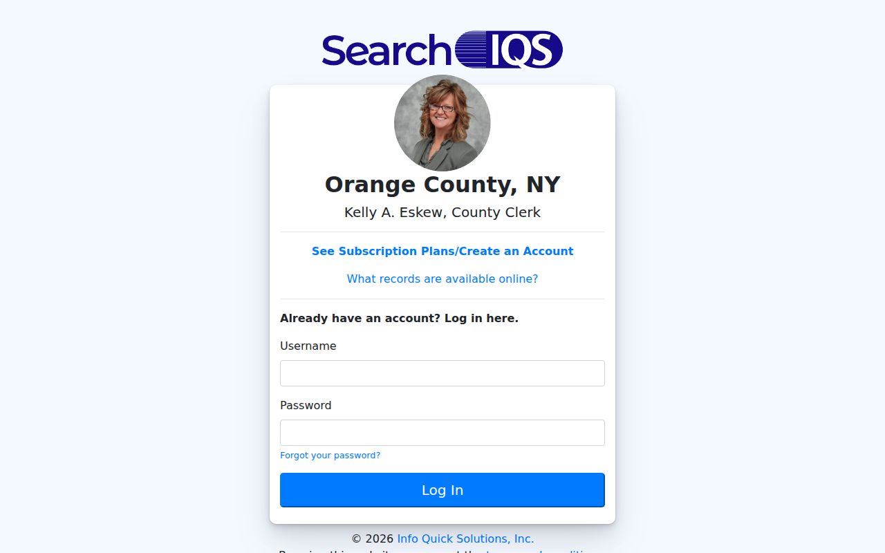
A deed may settle ownership history, but it does not certify present occupancy at the address.
New Windsor Street Buffer Searches
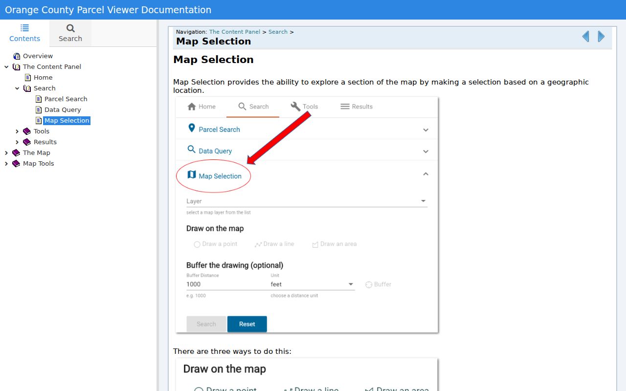
The GIS supports a wider by-street view when one parcel is not enough. In Map Selection, draw a point, line, or polygon, set a buffer distance, unit, and target, then run the search. Polygons need at least three points. The results can be zoomed, buffered again, exported as CSV, or printed as a report. Use the workflow to describe surrounding parcels, not to label people as residents.
Data Query is a separate tool for a selected layer and field. It accepts text contains searches and numeric operators such as <=, >=, and =. That is useful when a New Windsor street review needs a documented parcel characteristic rather than a name search.
The official data-query documentation shows the layer and operator approach.
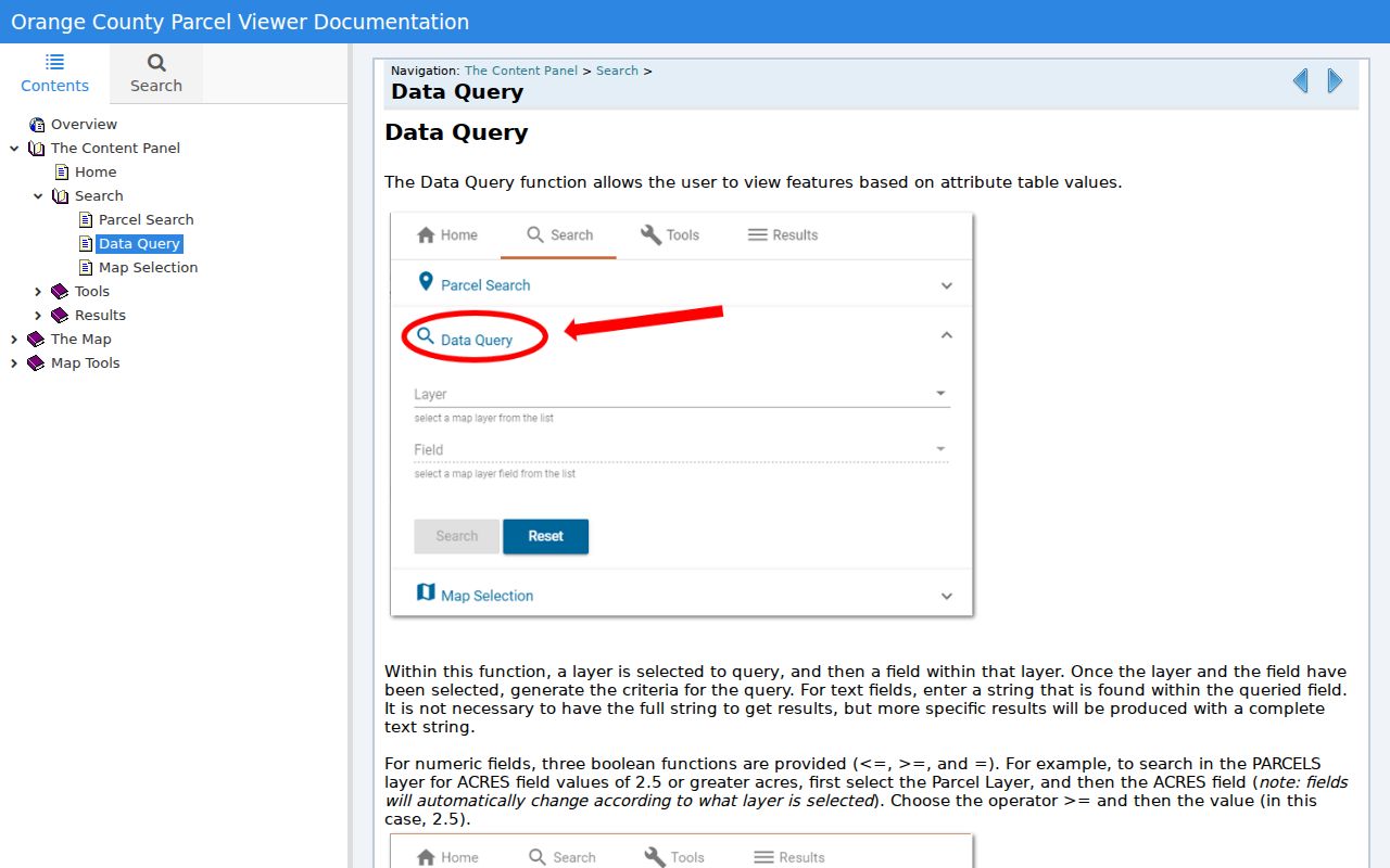
Save the layer name and query date with an export, since a CSV result is not a permanent record of ownership.
The map-selection instructions show the drawing and buffer controls used for adjacent parcels.
For the immediate block around one address, the parcel-buffer method is expanded on the New Windsor neighbors page.
New Windsor Street Permit Records
Building and code records can answer a narrow address question that a parcel map cannot. New Windsor’s Building Department administers permits, inspections, local zoning, the New York State Uniform Fire Prevention and Building Code, and 911 building-number requirements. The research did not locate a public online index for town building permits or code cases. That absence is important: an online street directory search should not imply that every permit is searchable from a browser.
For a defined property question, contact the Building Department at 845-563-4618 or submit a town FOIL request. State the property address, municipality, approximate date range, and the precise record sought, such as a permit, inspection, or code file. A request tied to an address and time period gives staff a usable retrieval path. It also avoids treating an administrative record as proof that someone lived at the property.
Preserve the response date and any permit or file number with the parcel notes. Construction work can date an alteration, while an inspection entry can document an agency action. Neither result alone identifies everyone connected to the address.
New Windsor Street History Checks
Historic names are useful search variants. Little Britain, Rock Tavern, and Vails Gate appear in the town’s historical and zoning geography, and older material may use a named place rather than the modern town label. No official dated street-renumbering or readdressing project was located. When a road looks uncertain, compare the legal description, lot or block, subdivision map, historical directory year, and town historian materials before treating two printed addresses as the same place.
The Newburgh Historical Society notes a key directory break: volumes before 1918 are surname-alphabetical, while later runs can be searched by street. A past household trail belongs in the New Windsor historical directory collection; that source can supply context without turning an old listing into a current address claim.
Note: Use town and named-place variants together when a historical index does not recognize the modern mailing label.
Limits of a New Windsor Street Directory
A street directory built from public records cannot produce a complete household list. Assessment rolls are owner-centered, and their mailing address can be elsewhere. The voter portal is a matched individual lookup, not a street browser. Historical directories are editorial snapshots. Private utility and delivery accounts, DMV information, protected voter addresses, and Address Confidentiality Program locations are not ordinary street-search tools.
A town FOIL request should name the record type, address, and date range. For example, a request for a permit history at one address is specific enough for the custodian to evaluate. Asking for a general list of people on a road is not the same kind of request. The New Windsor FOIL form includes fields for the record address, date, subject, description, and release method.
Lawful personal use. Use New Windsor street records for legitimate property, history, family, or civic questions. Do not combine public details to stalk, harass, or intimidate anyone.